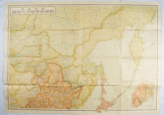
最新詳密蘇連極東地方大地図. [Saishin shomitsu Soren Kyokuto chiho dai chizu] [Most Recent and Detailed Large Map of the Soviet Union and Far East Region].
東京. [Tokyo]. 伊林書店. [Ibayashi Shoten]. 昭和14 [ 1939]. Colour printed folding map, 78 X 109cm, minor damage original envelope (27.5 x 20cm). Very good copy. This map offers comprehensive information on the northern China, Manchuria, the Soviet Union and Hokkaido, including Kuril Islands under the Japanese control. It also includes..... More