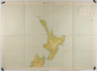
二百万分一太平洋周域(南部)輿地図1号. ニュージーランド北部. [Nihyakuman-bun-no-ichi Taiheiyō shūiki (nambu) yochizu 1-gō. Nyū Jīrando hokubu]. [Southern Pacific Rim Map No. 1. Northern New Zealand. 1:2000000].
東京. [Tokyo]. 大日本帝国陸地測量部. [Dainihon Teikoku Rikuchi Sokuryōbu]. Showa 17 [ 1942]. Folding colour map, scale 1:2000000, 110 x 80 cm, map title pencilled in reverse. Light toning, otherwise very good. This map of northern New Zealand was published by the Japanese Imperial Land Survey Section in 1942. Legends include private..... More
![Stock ID #160524 東部亜細亜圖. 五百万分一. [Tobu Ajiazu. Gohyakumanbunnoichi].[East...](https://asiabookroom.cdn.bibliopolis.com/pictures/160524.jpg?width=320&height=427&fit=bounds&auto=webp&v=1713235705)