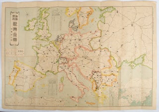
海陸軍用欧州全図. 附東洋方面. [Kairikugunyō Ōshū zenzu. Fu Tōyō hōmen]. [Complete Map of Europe Showing Comparative Naval and Army Strength. Additional Map of the Far East].
東京. [Tokyo]. 東京朝日新聞社. [Tōkyō Asahi Shinbunsha]. 大正 3 [ 1914]. Colour folding map, 54.5 x 78cm, inset map showing Europe, Asia and North Africa. Light even browning and foxing, small stain in one section but otherwise good. This map was published as a supplement in September 1st, 1914, Tokyo Asahi..... More