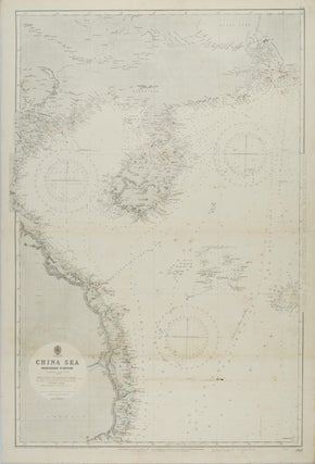
China Sea. Northern Portion, Western Sheet. [Hong Kong to Cape Padaran, Cochin China].
London. Admiralty. 1929. Large black and white coastal chart, 103 x 70.5cm, horizontal fold, a little light browning and soiling, neat manuscript highlighting beacons, good copy. Compiled from the latest surveys to 1884 corrected to 1929, with a large correction in 1926. Includes arrows indicating the direction and strength of..... More
![Stock ID #154409 New Zealand. Philips's Series of Travelling Maps. [Polynesia - Sheet title]. J....](https://asiabookroom.cdn.bibliopolis.com/pictures/154409.jpg?width=320&height=427&fit=bounds&auto=webp&v=1697759215)
![Stock ID #177874 [Turkey: 19th Century music covers]. AUGUSTUS BUTLER, J. BRANDARD, M. HANHART,...](https://asiabookroom.cdn.bibliopolis.com/pictures/177874.jpg?width=320&height=427&fit=bounds&auto=webp&v=1706591818)
![Stock ID #177262 Investigating the Composition of the Great Wall of China. [Caption title]. C. W....](https://asiabookroom.cdn.bibliopolis.com/pictures/177262.jpg?width=320&height=427&fit=bounds&auto=webp&v=1697782624)
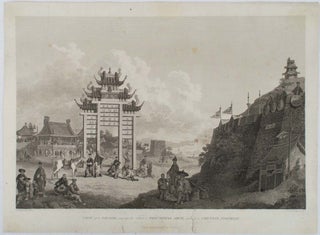
![Stock ID #177643 View of one of the Western Gates of the City of Pekin. [caption title]. EMBASSY...](https://asiabookroom.cdn.bibliopolis.com/pictures/177643.jpg?width=320&height=427&fit=bounds&auto=webp&v=1707789742)
![Stock ID #178445 Macao from Penha Hill. [caption title]. COMMODORE MATTHEW PERRY, WILHELM HEINE,...](https://asiabookroom.cdn.bibliopolis.com/pictures/178445.jpg?width=320&height=427&fit=bounds&auto=webp&v=1712648660)
![Stock ID #176746 Napha from the Sea. [Caption title]. COMMODORE MATTHEW PERRY, WILHELM HEINE,...](https://asiabookroom.cdn.bibliopolis.com/pictures/176746.jpg?width=320&height=427&fit=bounds&auto=webp&v=1697780856)