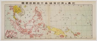
比島及東印度諸島方面戦局要図. [Hitō oyobi Higashi Indo Shotō hōmen senkyoku yōzu]. [Japanese Campaign Map of the Philippines and Dutch East Indies Areas].
[Japan]. 1942? Colour map, 21 x 50.5 cm, centrefold as issued. Faint dampstain to upper edge, centrefold a little browned. Good copy. Map of Southeast Asia, including Borneo and the Philippines and New Guinea. Of particular interest is the small inset map of Singapore at lower left. The war situation..... More