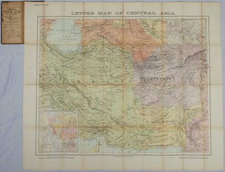
Letts's Large Print Map of Central Asia. Chiefly compiled from British and Russian official plans and books.
London Bridge. Letts, Son & Co. Limtd. Map Publishers. n.d. c 1885. Second Edition. Large colour folding map of Persia, Afghanistan, Beluchistan, Khorasan, Mekran, Kerman, Russia and the southern Caspian. Two smaller inset maps, one showing England to India and the other showing 'Acquisitions of Russia in Europe and Asia'..... More