![Stock ID #169768 抗美援朝時事學習地圖. [Kang Mei yuan Chao shi shi xue xi di tu]. [Current Affairs Study Map - Resisting US Aggression and Aiding Korea]. YA XIN CARTOGRAPHIC STUDY SOCIETY, 亞新地學社.](https://asiabookroom.cdn.bibliopolis.com/pictures/169768.jpg?width=768&height=1000&fit=bounds&auto=webp&v=1710492328)
![抗美援朝時事學習地圖. [Kang Mei yuan Chao shi shi xue xi di tu]. [Current Affairs Study Map - Resisting US Aggression and Aiding Korea].](https://asiabookroom.cdn.bibliopolis.com/pictures/169768_2.jpg?auto=webp&v=1710492328)
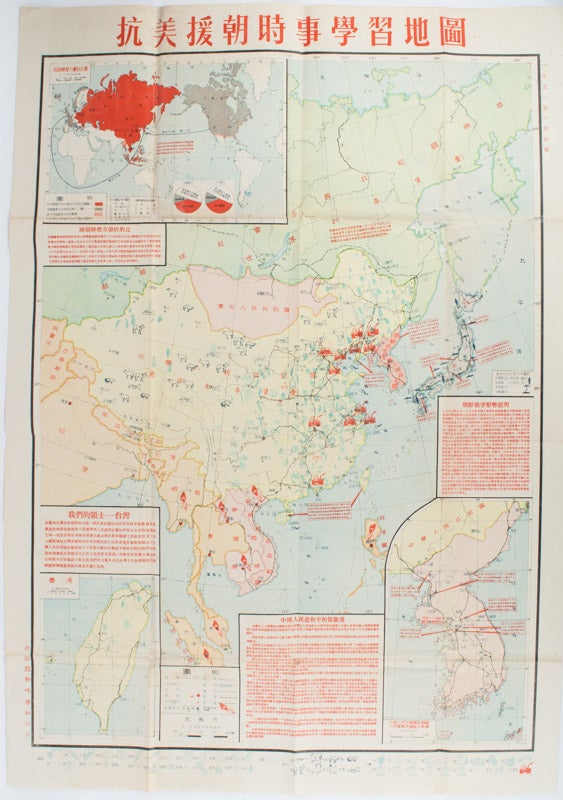
抗美援朝時事學習地圖. [Kang Mei yuan Chao shi shi xue xi di tu].
[Current Affairs Study Map - Resisting US Aggression and Aiding Korea].
武昌.[Wuchang]. 亞新地學社.[Ya xin di xue she]. August 1951. 1st Edition. Stock ID #169768 On the map China is named 東方和平堡壘 "The Oriental Peace Fortification" and Soviet Union 世界和平堡壘 "The World's Peace Fortification". Red torches alight across many Southeast Asian nations including Vietnam, Burma, Cambodia, Malaysia, Indonesia and Philippines, indicating those nations were undergoing liberation wars. Taiwan and Hainan are described as the two eyes on Chinese seas. Many American navy bases, air bases and armed forces are shown in locations all over Japan. When referring to this item please quote stockid 169768.
Large detailed colour Chinese map of Korean War, folded, scale 1:15,000,000, three inset maps on corners, illustrated legend showing agricultural and mining resources lower margin, in original envelope. Some light wear along edges, small holes and wear at folds mended with archival tape, envelope torn with loss mended with archival tape.
Inset map 兩個陣營力量對比 "Strength Comparison Between The Two Camps" upper left corner, scale 1: 170,000,000. The Peaceful Camp in red covering the majority of Asia and Europe, a list of 6 countries (Germany, Czech, Hungary, Romania, Bulgaria, Albania) are numbered and are also part of the Peaceful Camp. The Invader Camp in grey covering North America and small parts of Europe, a list of 3 nations (Netherlands, Belgium, Luxembourg) are numbered and are also part of the Invader Camp. Block of text in red beneath the map compares the two camps from the aspects of territorial areas, natural resources and economy. It points out that the Invader Camp led by the United States is a paper tiger which will be destroyed by the people of the world. A pie chart also drawn in the map showing population comparison.
Inset map 中國人民志願軍與朝鮮人民軍曆次殲敵形勢圖 "Situation Map of Eliminating Enemies by the People's Volunteer Army and the Korean People's Army" lower right corner, scale 1:4,500,000. From October 1950 to April 1951, five battles were recorded with a claimed total number of 188,000 enemies killed. Block of text in red above the map gives an analysis of the Korean War so far.
Inset map 臺灣 "Map of Taiwan", scale 1:2,500,000. Block of text in red above the map states that Taiwan has always been a part of China. At moment, however, Taiwan is occupied by the American imperialists and Jiang bandits. The evil coalition will be one day kicked out of Taiwan, and Taiwan will be back to the army of the motherland.
Very rare map with historical and research importance. Text in traditional Chinese. Sheet measures 78 x 54.7cm.
Price: $2,750.00 AU