![Stock ID #157907 Street Map of the Cities of Ubon Ratchathani & Warin Chamrap. แผนที่แสดงถนนในเขต อุบลราชธานี และ วารินชำราบ. [Phǣnthī sadǣng thanon nai khēt ʻUbon Rātchathāni læ Wārin Chamrāp]. BRENDAN WHYTE, FIELDWORK AND MAPPING BY.](https://asiabookroom.cdn.bibliopolis.com/pictures/157907.jpg?width=768&height=1000&fit=bounds&auto=webp&v=1697761042)
![Street Map of the Cities of Ubon Ratchathani & Warin Chamrap. แผนที่แสดงถนนในเขต อุบลราชธานี และ วารินชำราบ. [Phǣnthī sadǣng thanon nai khēt ʻUbon Rātchathāni læ Wārin Chamrāp]](https://asiabookroom.cdn.bibliopolis.com/pictures/157907_2.jpg?auto=webp&v=1697761042)
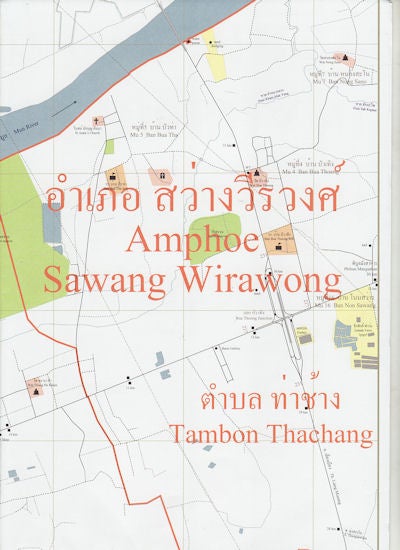
Street Map of the Cities of Ubon Ratchathani & Warin Chamrap. แผนที่แสดงถนนในเขต อุบลราชธานี และ วารินชำราบ. [Phǣnthī sadǣng thanon nai khēt ʻUbon Rātchathāni læ Wārin Chamrāp]
Ubon Ratchathani. Faculty of Management Science, Ubon Ratchathani University. 2008. Stock ID #157907 Covering an area of over 270 square kilometres these detailed maps show the area to beyond the ring road. Includes bus routes, schools, temples, churches & mosques, hospitals, hotels and restaurants, cinemas, museums and libraries, petrol and LPG stations, parks and golf courses, government offices, amphoe (districts), tambon (subdistricts) and muban (villages), landmarks and places of interest. When referring to this item please quote stockid 157907.
4 bilingual Thai/English street maps (using the Royal Institute's General System of Transcription) of Ubon Ratchathani and Warin Chamrap, in northeast Thailand. Covers the entire urban area to beyond the Ring Road. Printed colour, measures 21 x 30cm folded. Unfolded Scale 1:14,200 with enlargements of central Ubon Ratchathani and Warin Chamrap 1:6,500. As new in plastic folder with information sheet.
Price: $20.00 AU