![Stock ID #160561 蘭領東印度諸島詳圖 附泰國・佛印・マレー半島. [Ranryo Higashi Indo shoto shozu : Fu Taikoku Futsuin Mare hanto]. Malay Archipelago. KOYAMA YOSHIMITSU, 小山吉三.](https://asiabookroom.cdn.bibliopolis.com/pictures/160561.jpg?width=768&height=1000&fit=bounds&auto=webp&v=1699558333)
![蘭領東印度諸島詳圖 附泰國・佛印・マレー半島. [Ranryo Higashi Indo shoto shozu : Fu Taikoku Futsuin Mare hanto]. Malay Archipelago.](https://asiabookroom.cdn.bibliopolis.com/pictures/160561_2.jpg?auto=webp&v=1699558333)
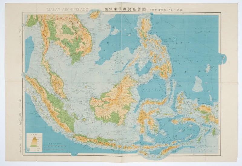
蘭領東印度諸島詳圖 附泰國・佛印・マレー半島. [Ranryo Higashi Indo shoto shozu : Fu Taikoku Futsuin Mare hanto].
Malay Archipelago.
東京.[Tokyo]. 日本名所圖繪社. Showa 17 [ 1942]. Stock ID #160561 Japanese troops took over the Dutch East Indies from the Netherlands during World War II from March 1942 until after the end of the War in September 1945. When referring to this item please quote stockid 160561.
Folding Japanese coloured map of the Malay Archipelago and Thailand during World War II, with attractive original pictorial paper slipcase. It depicts parts of Thailand, Hainan Province and South China Sea, Sumatra and Java Sea, Borneo, Philippine Islands, Celebes, Timor, New Guinea and parts of Micronesia. Natural resources such as tobacco, spices, wood, sugar, metal mines (tin, iron and etc.), rice and other resources are indicated on the map. Scale 1:8500000. Legend in lower corner indicates altitudes. Some tears, mainly closed, on folds and edges, some of which have been repaired with tape on reverse. Text in Japanese and English. 52.2 x 75cm.
Price: $260.00 AU