![Stock ID #163241 懷玉 三河州地理圖鑒. [Kaigyoku Mikawa-shū chiri zukan]. [Geographic Guide to the Area around Mikawa]. 巌谿山人.](https://asiabookroom.cdn.bibliopolis.com/pictures/163241.jpg?width=768&height=1000&fit=bounds&auto=webp&v=1692011006)
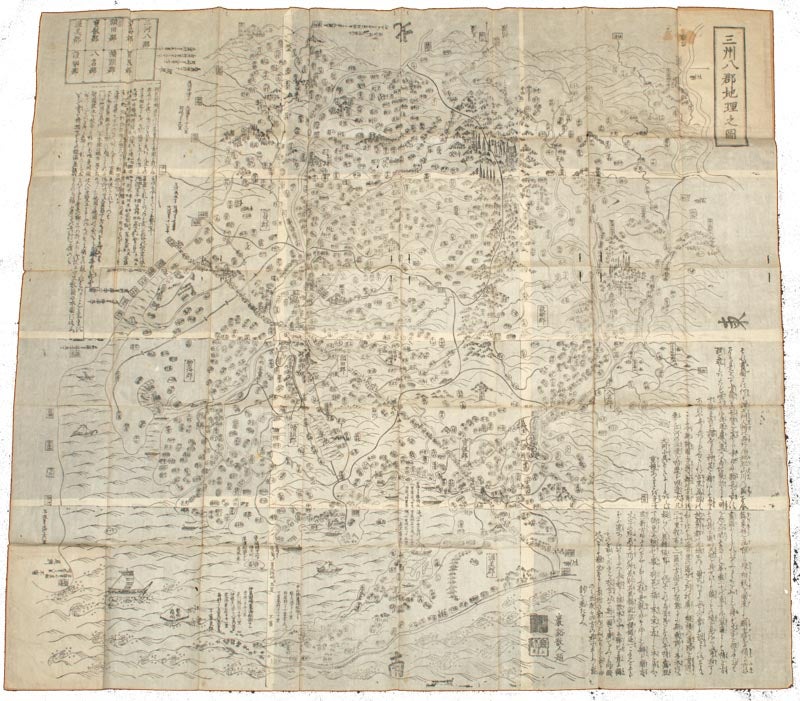
懷玉 三河州地理圖鑒. [Kaigyoku Mikawa-shū chiri zukan].
[Geographic Guide to the Area around Mikawa].
No date. (Edo - 18th Century). Stock ID #163241 Published in the middle to late Edo period this detailed and attractive map shows 三河国 Mikawa no kuni, a province that no longer exists, but found within today's boundaries of the eastern half of Aichi Prefecture in Japan. The famed Tokaido Road ran through this province. The name of this area is sometimes abbreviated to Sanshū 三州 which is also on this map. The map covers the following districts: 三河 Mikawa Province; 碧海郡 Hekikai District; 額田郡 Nukata District; 幡頭郡Hazu District; 宝飯郡 Hoi District; 八名郡 Yana District; 渥美郡 Atsumi District and 設楽郡 Shitara District, some of which no longer exist. This striking pictorial map shows ships in the sea, mountains and trees. Scarce. When referring to this item please quote stockid 163241.
Handsome black and white woodblock pictorial folded map in original card covers with paper title label. Occasional light spotting and toning along folds, paper covers little insect damaged and marked, a few small areas of worming at margins. Very good. 110.3 x 119.5cm.
Price: $2,500.00 AU