![Stock ID #174862 大東京漫画地図. [Dai Tōkyō manga chizu]. [Pictorial Map of Greater Tokyo]. ISHIDA EISUKE, 石田英助.](https://asiabookroom.cdn.bibliopolis.com/pictures/174862.jpg?width=768&height=1000&fit=bounds&auto=webp&v=1710492329)
![大東京漫画地図. [Dai Tōkyō manga chizu]. [Pictorial Map of Greater Tokyo].](https://asiabookroom.cdn.bibliopolis.com/pictures/174862_2.jpg?auto=webp&v=1710492329)
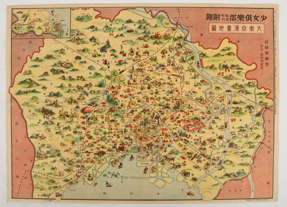
大東京漫画地図. [Dai Tōkyō manga chizu].
[Pictorial Map of Greater Tokyo].
東京. [Tokyo]. 大日本雄弁会講談社 [Dainihon Yūbenkai Kōdansha]. Showa 12 [ 1937]. Stock ID #174862 This beautifully illustrated colour pictorial map of the Greater Tokyo was issued as a supplement to Shojo Kurabu (Girls' Club) magazine on July 1937. This monthly magazine was very popular amongst teenage girls with monthly print runs of about half a million copies in 1937. When referring to this item please quote stockid 174862.
Very attractive colour pictorial folding map, black and white photographic illustrations on reverse, lightly creased at fold lines, some small, closed tears repaired with archival tape but generally in very good condition. 39 x 53.7 cm.
The map covers Greater Tokyo and is most attractively illustrated with detailed manga style illustrations of major buildings, sightseeing spots additionally various images of people such as soldiers, university students, school pupils, factory workers and farmers bring a pleasing liveliness to the map. The illustrator, Ishida Eisuke (1914-2010), had a long and successful career as a manga artist in post-war Japan.
Twenty-seven black and white photographic illustrations on the reverse show the major attractions in Tokyo, including the Imperial Palace and the Kabukiza Theatre. Many of the buildings and structures shown were destroyed during the Pacific War.
Price: $275.00 AU