![Stock ID #175817 大日本細見道中図鑑. [Dai Nihon saiken dōchū zukan]. [Pictorial Map of Greater Japan and its Roads]. ICHIBEI IZUMIYA, 和泉屋市兵衛.](https://asiabookroom.cdn.bibliopolis.com/pictures/175817.jpg?width=768&height=1000&fit=bounds&auto=webp&v=1699562905)
![大日本細見道中図鑑. [Dai Nihon saiken dōchū zukan]. [Pictorial Map of Greater Japan and its Roads].](https://asiabookroom.cdn.bibliopolis.com/pictures/175817_2.jpg?auto=webp&v=1699562905)
![大日本細見道中図鑑. [Dai Nihon saiken dōchū zukan]. [Pictorial Map of Greater Japan and its Roads].](https://asiabookroom.cdn.bibliopolis.com/pictures/175817_3.jpg?auto=webp&v=1699562905)
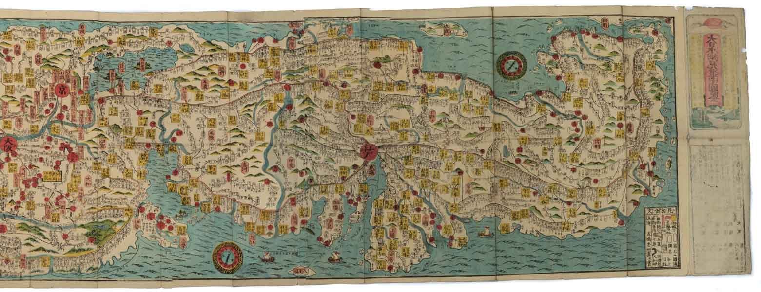
大日本細見道中図鑑. [Dai Nihon saiken dōchū zukan].
[Pictorial Map of Greater Japan and its Roads].
大阪. [Osaka]. 石川屋和助. [Ishikawaya Wasuke]. (Circa 1865). Stock ID #175817 This colourful and attractive pictorial map of Japan from around 1865 shows the mainland Japan, Shikoku and Kyushu. Hokkaido and Ryukyu are not included. The map can be folded into a compact size (18.3 x 8.7 cm) and a relevant section can be read without unfoldiing the whole map. Various roads, including the Tokaido, the Nakasendo, the Kiso and the Oshu are marked as well as some pilgrim routes of Ise, Saigoku and Konpira routes. Legends include castle towns, border checking gates, famous shrines and temples, and 33 temples of the Western Japan Pilgrimage are marked as well as sea routes. Detailed names of towns and villages as well as some topographical features of rivers and mountains appear throughout the map. The map was used for travelling as well as for tourism. Some useful items for traveling, such as rain jackets, towels and a small abacus, are listed on the last page as suggestions. When referring to this item please quote stockid 175817.
Attractive colour woodblock map, 38 x 197 cm, folded 18.3 x 8.7 cm. A little worming in places on the map and cover, light soiling on colour pictorial cover and lower cover but still a very attractive map.
Price: $495.00 AU