![Stock ID #177466 学習日満地図. 附統計図表. [Gakushū Nichiman chizu. Fu tōkeizuhyō]. [Study Map of Japan and Manchuria with Statistical Charts]. KAWAMURA KINJIRŌ, 川村欽次郎.](https://asiabookroom.cdn.bibliopolis.com/pictures/177466.jpg?width=768&height=1000&fit=bounds&auto=webp&v=1697782630)
![学習日満地図. 附統計図表. [Gakushū Nichiman chizu. Fu tōkeizuhyō]. [Study Map of Japan and Manchuria with Statistical Charts].](https://asiabookroom.cdn.bibliopolis.com/pictures/177466_2.jpg?auto=webp&v=1697782630)
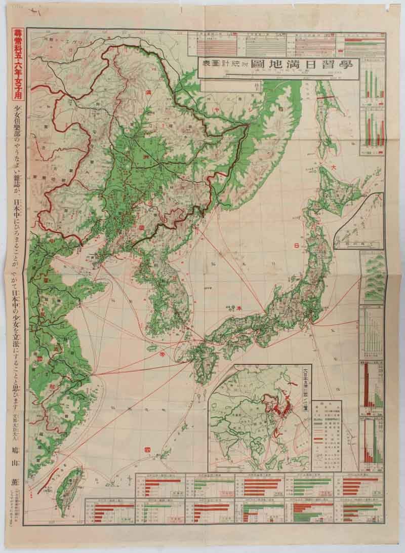
学習日満地図. 附統計図表. [Gakushū Nichiman chizu. Fu tōkeizuhyō].
[Study Map of Japan and Manchuria with Statistical Charts].
東京. [Tokyo]. 大日本雄辯會講談社. [Dai Nihon Yūbenkai Kōdansha]. Showa 7 [ 1932]. Stock ID #177466 This map which was specifically published for Year 5 and 6 girls was issued as a supplement to the very popular magazine 少女倶楽部(Shōjo Kurabu)"Girl's Club" in December 1932. When referring to this item please quote stockid 177466.
Colour folding map, 54 x 39 cm, inset map and charts, some minor paper loss in the upper margin, not affecting the map, colourful advertisement for the new year issue of the magazine can be seen on the reverse.
Published the year Manchukuo was established, the inset map and charts show: Location of Japan and Manchuria, a comparison of import and export trade of Kobe and Yokohama, a comparison of river and mountain heights, as well as production of various resources including coal, iron ore and forestry produce. The charts clearly indicating to the young students that Manchuria rich in natural resources. A printed endorsement on the margin of the map by Mrs Hatoyama Kaoru, an educator and wife of Hatoyama Ichiro, tells us that the wider distribution of the Shojo Kurabu magazine throughout Japan would contribute to Japanese girls' education and make them respectable citizens.
The striking coloured advertisement on the reverse of the map advertises the numerous supplements, stories and prizes which will be featured in the new year issue of the magazine.
Price: $350.00 AU