![Stock ID #177489 南方圏時局資源精図. [Nanpoken jikyoku shigen seizu]. (Detailed Map of the Current Situation and Resources to the South). OBUNSHA HENSHUKYOKU, 欧文社編輯局.](https://asiabookroom.cdn.bibliopolis.com/pictures/177489.jpg?width=768&height=1000&fit=bounds&auto=webp&v=1699564704)
![南方圏時局資源精図. [Nanpoken jikyoku shigen seizu]. (Detailed Map of the Current Situation and Resources to the South).](https://asiabookroom.cdn.bibliopolis.com/pictures/177489_2.jpg?auto=webp&v=1699564704)
![南方圏時局資源精図. [Nanpoken jikyoku shigen seizu]. (Detailed Map of the Current Situation and Resources to the South).](https://asiabookroom.cdn.bibliopolis.com/pictures/177489_3.jpg?auto=webp&v=1699564704)
![南方圏時局資源精図. [Nanpoken jikyoku shigen seizu]. (Detailed Map of the Current Situation and Resources to the South).](https://asiabookroom.cdn.bibliopolis.com/pictures/177489_4.jpg?auto=webp&v=1699564705)
![南方圏時局資源精図. [Nanpoken jikyoku shigen seizu]. (Detailed Map of the Current Situation and Resources to the South).](https://asiabookroom.cdn.bibliopolis.com/pictures/177489_5.jpg?auto=webp&v=1699564705)
![南方圏時局資源精図. [Nanpoken jikyoku shigen seizu]. (Detailed Map of the Current Situation and Resources to the South).](https://asiabookroom.cdn.bibliopolis.com/pictures/177489_6.jpg?auto=webp&v=1699564704)
![南方圏時局資源精図. [Nanpoken jikyoku shigen seizu]. (Detailed Map of the Current Situation and Resources to the South).](https://asiabookroom.cdn.bibliopolis.com/pictures/177489_7.jpg?auto=webp&v=1699564704)
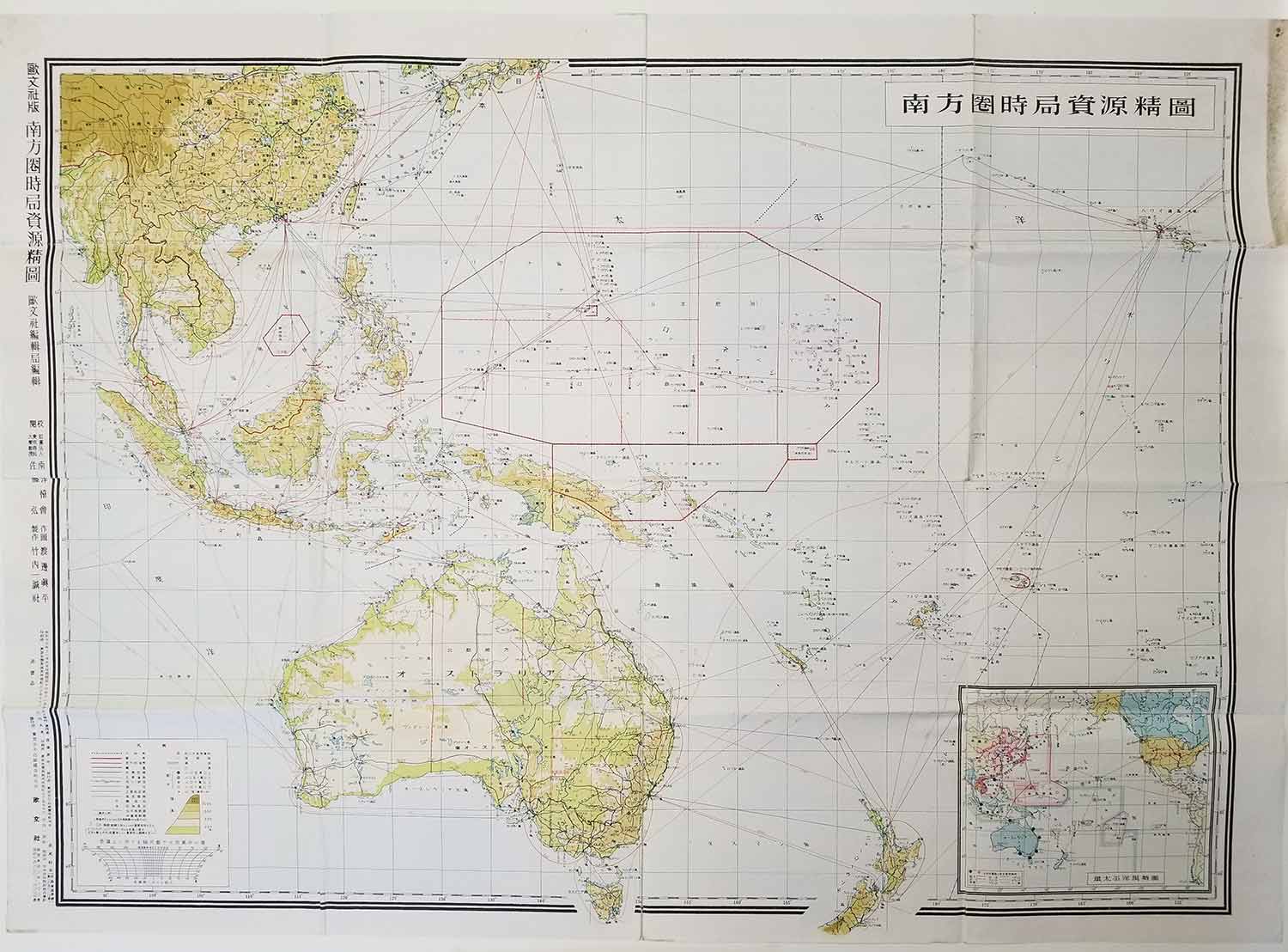
南方圏時局資源精図. [Nanpoken jikyoku shigen seizu].
(Detailed Map of the Current Situation and Resources to the South).
東京. [Tokyo]. 欧文社. [Obunsha]. Showa 16 [ 1941]. Stock ID #177489 An independently issued map, published on 15 November 1941, just weeks before the Japanese attack on Pearl Harbor. The map covers the southern part of China, Southeast Asia and the Philippines, all of Australia and the greater part of New Zealand with markings of natural resources in red. There is an inset map of the Pacific Region. When referring to this item please quote stockid 177489.
Colour folding map of Oceania, Southeast Asia and islands of the North Pacific Ocean. Relief shown by spot heights and gradient tints, 61 x 85.2cm, folds to 21 x 16cm. Map is overall in very good condition: there are tiny separations at a couple of folding points, light wear at the lower centre fold, soiling in the right hand margin of the top panel (well outside the map image), some light creasing. Complete with the original paper wrapper (a little soiled.)
Price: $325.00 AU