![Stock ID #178768 越南人民抗美救国形势图. [Yuenan ren min kang mei jiu guo xing shi tu]. [Illustrated Situation Map of the Vietnamese People's Saving of Vietnam and Resistance to the United States]. YULIAN ZHU, 朱育蓮 绘, CARTOGRAPHER.](https://asiabookroom.cdn.bibliopolis.com/pictures/178768.jpg?width=768&height=1000&fit=bounds&auto=webp&v=1699565533)
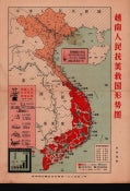
越南人民抗美救国形势图. [Yuenan ren min kang mei jiu guo xing shi tu].
[Illustrated Situation Map of the Vietnamese People's Saving of Vietnam and Resistance to the United States].
No place of publication. No publisher. (circa January 1966). Stock ID #178768 Chinese military situation map depicting the battles between Vietnam and United States in August 1965. The map also covers parts of southern China (Hainan, Guangdong and Guangxi provinces), Cambodia, Laos and Thailand. Locations of southern Vietnamese landslide victories over American troops are shown, American naval and air force bases (including some super-size air force bases), roads, railway lines and provincial boundaries are also featured on the map. When referring to this item please quote stockid 178768.
Very interesting Chinese coloured map of Vietnam published during the Vietnam War, horizontal fold, scale not given. Occasional browning, little creased. Text in Chinese. Map measures 35.4 x 25.7cm.
Explanatory notes on upper section and left lower corner state that in the period between August 1964 and January 1966, 857 US aircraft were shot down by the North Vietnamese army and civilians. It also includes the number of enemy (483,500) including US troops (22,766) killed and the number of army transportation vehicles (aircraft, ships and cars) destroyed between 1961 and 1965 by the South Vietnamese people. At the bottom left, a chart illustrates the US troop deployment to South Vietnam. It graphically demonstrates the build up in numbers between 1961, with 3,500 US soldiers in the country, to 200,000 by the late sixties.
Price: $425.00 AU