
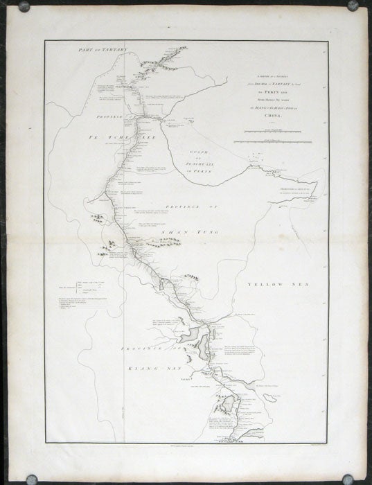
A Sketch of a Journey from Zhe-Hol in Tartary by land to Pekin and from thence by water to Hang-Tchoo-Foo in China.
London. George Nicol. 1796. Stock ID #207049 An exquisitely engraved map with fine detail of the route taken by George Macartney on the first official British embassy to China 1792-1794, undertaken with the aim of gaining trade concessions from the Chinese Emperor and published in George Staunton's officall account. When referring to this item please quote stockid 207049.
Double-sheet engraved copperplate map, 63.2 x 44.8 cm; 75 x 57 cms (sheet including platemark), central fold, the sheet toned at the edges and central fold, a couple of minor spots and edge wear, but in very good condition.
While the official purpose was not successful, much was learned about China and the Chinese as is evident from this map with its explanatory texts. To the west of Pekin, just below the starting point at Zhe-hol (Jehol) which is situated at the top of this map, the commentary reads: "A great part of the country around Pekin is employed in the production of culinary vegetables and a variety of fruits." At the lower edge of the map, just north of the ending point of Hangzhou is the lake Tai Hoo: "The western side of the Tai-hoo is bounded by a very romantic and fertile country whose mountains are clutivated to their very tops. A great part of the province of Tche-tchiang appears to be cultivated with Mulberry trees for the food of the Silk worms." Cities of the 1st, 2nd and 3rd orders, "considerable towns" and villages are marked, along with "Halting places" etc. Fascinating Western documentation of the area around the Imperial Canal of the late Eighteenth Century.
Price: $825.00 AU