![Stock ID #215028 [黒船渡来御固図]. [Kurofune torai onkatamezu]. [Defending Map against...](https://asiabookroom.cdn.bibliopolis.com/images/noimage.png?auto=webp)
[黒船渡来御固図]. [Kurofune torai onkatamezu]. [Defending Map against the Arrival of the Black Fleet].
[Japan]. [ 1854]? Black and white woodblock map with illustrations, 32.2 x 41.5cm. Laid down on thick paper. Printed black border line at lower corner and occasionally in other areas along the border not printed, otherwise good. This woodblock print map shows the defence layout around Tokyo Bay against the..... More
![Stock ID #214269 絵入鳥瞰東亜現勢地図. [Eiri Chokan Toa Gensei Chizu] [Illustrated...](https://asiabookroom.cdn.bibliopolis.com/pictures/214269.jpg?width=320&height=427&fit=bounds&auto=webp&v=1699570947)
![Stock ID #215556 上海地圖 交通最新路綫. [Shanghai ditu Jiaotong zui xin luxian]....](https://asiabookroom.cdn.bibliopolis.com/pictures/215556.jpg?width=320&height=427&fit=bounds&auto=webp&v=1710493344)
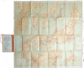
![Stock ID #177980 日本見学絵とき地図. [Nihon kengaku etoki chizu]. [Pictorial Maps...](https://asiabookroom.cdn.bibliopolis.com/pictures/177980.jpg?width=320&height=427&fit=bounds&auto=webp&v=1710493339)
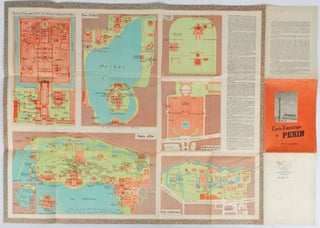
![Stock ID #169765 Map of Peking. 京城內外全圖 .[Jing cheng nei wai quan tu]. BOXER...](https://asiabookroom.cdn.bibliopolis.com/pictures/169765.jpg?width=320&height=427&fit=bounds&auto=webp&v=1697771802)
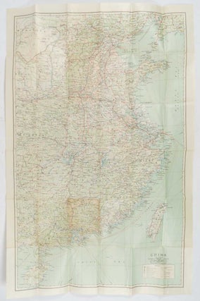
![Stock ID #137007 中國交通旅行圖. [Zhongguo jiao tong lü xing tu]. [Transportation Tourist...](https://asiabookroom.cdn.bibliopolis.com/pictures/137007.jpg?width=320&height=427&fit=bounds&auto=webp&v=1697755624)
![Stock ID #214208 法国地图. [Faguo di tu]/法国人民革命斗争示意图. [Faguo ren min ge...](https://asiabookroom.cdn.bibliopolis.com/pictures/214208.jpg?width=320&height=427&fit=bounds&auto=webp&v=1710493347)