![Stock ID #160533 蘭領東印度諸島詳圖 附泰國・佛印・マレー半島. [Ranryo Higashi Indo shoto shozu : Fu Taikoku Futsuin Mare hanto]. Malay Archipelago. KICHIZŌ 小山吉三 KOYAMA.](https://asiabookroom.cdn.bibliopolis.com/pictures/160533.jpg?width=768&height=1000&fit=bounds&auto=webp&v=1697762833)
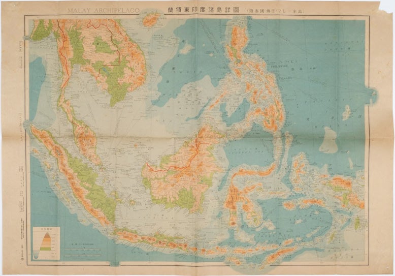
蘭領東印度諸島詳圖 附泰國・佛印・マレー半島. [Ranryo Higashi Indo shoto shozu : Fu Taikoku Futsuin Mare hanto].
Malay Archipelago.
Tokyo. 日本名所圖繪社.[Nihon Meisho Zuesha]. 昭和 17 [ 1942]. Stock ID #160533 This map shows most of Thailand, former Indochina, Hainan Province and South China Sea, Sumatra and Java Sea, Borneo, the Philippine Islands, Celebes, Timor, New Guinea and parts of Micronesia. Natural resources such as tobacco, spices, wood, sugar, metal mines (tin, iron and etc.), rice and other resources are indicated on the map. When referring to this item please quote stockid 160533.
Folding Japanese coloured map of the Malay Archipelago and Thailand during World War II, scale 1:8500000. Legend in lower corner indicates altitudes. Ink annotation in Japanese left edge. Pin holes at three corners, upper right corner torn with loss, evenly browned, otherwise very good. Text in Japanese and English. 52.8 x 75.6cm.
Price: $250.00 AU