![Stock ID #160545 佛印・蘭印要圖. 朝日カレンダー・ニユース地圖版. [Futsu-In, Ran-In Yozu. Asahi Karenda Nyusu Chizuban]. [Detailed Map of Southeast Asia. Daily Calendar News Version]. THE ASAHI SHIMBUN, 朝日新聞社.](https://asiabookroom.cdn.bibliopolis.com/pictures/160545.jpg?width=768&height=1000&fit=bounds&auto=webp&v=1710491528)
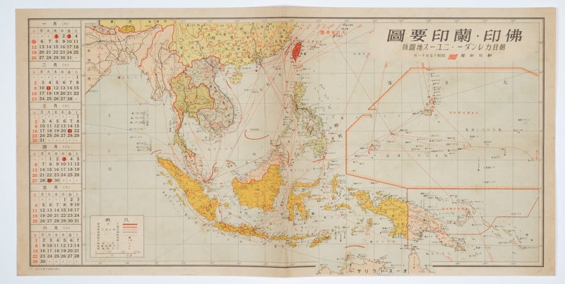
佛印・蘭印要圖. 朝日カレンダー・ニユース地圖版. [Futsu-In, Ran-In Yozu. Asahi Karenda Nyusu Chizuban].
[Detailed Map of Southeast Asia. Daily Calendar News Version].
No place of publication. 朝日新聞社. [The Asahi Shimbun]. 昭和十五[ 1940]. Stock ID #160545 Legend at lower left lists the boundaries between continents, countries and provincials or regions, railways, airline routes, capitals, and Japanese embassies and consulates. When referring to this item please quote stockid 160545.
Published by 朝日新聞社 [The Asahi Shimbun], Japanese folding coloured WWII map with a calendar from January to June Shōwa 15 at the left, scale 1:300,000. Map includes French Indochina, Dutch East Indies, and parts of the territory of Papua, China and British India. Some light browning and foxing, otherwise very good. Text in Japanese. 25.3 x 51cm.
The natural resources are indicated across the map. The map also shows parts of the territory of Papua under Australia's administration " 濠洲委任統治領 [Gōshū inin tōchiryō]".
Price: $300.00 AU