![Stock ID #171702 海陸軍用欧州全図. 附東洋方面. [Kairikugunyō Ōshū zenzu. Fu Tōyō hōmen]. [Complete Map of Europe Showing Comparative Naval and Army Strength. Additional Map of the Far East]. TŌKYŌ ASAHI SHINBUNSHA, 東京朝日新聞社.](https://asiabookroom.cdn.bibliopolis.com/pictures/171702.jpg?width=768&height=1000&fit=bounds&auto=webp&v=1699561061)
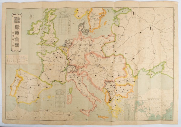
海陸軍用欧州全図. 附東洋方面. [Kairikugunyō Ōshū zenzu. Fu Tōyō hōmen].
[Complete Map of Europe Showing Comparative Naval and Army Strength. Additional Map of the Far East].
東京. [Tokyo]. 東京朝日新聞社. [Tōkyō Asahi Shinbunsha]. 大正 3 [ 1914]. Stock ID #171702 This map was published as a supplement in September 1st, 1914, Tokyo Asahi Newspaper just weeks after the start of World War 1 in Europe. The map identifies two warring sides using green and pink. It also shows the positioning of army corps, divisions and brigades as well as military ports, flying units and railways. An inset map shows relative positioning of Japan and Europe. Inset charts show the strength of the naval fleets in the North Sea and the Mediterranean. Even though the conflict was taking place far from Japanese shores, the issuing of this map as a supplement by the very popular Asahi Newspaper, clearly demonstrates the keen interest the Japanese public felt in the conflict. When referring to this item please quote stockid 171702.
Colour folding map, 54.5 x 78cm, inset map showing Europe, Asia and North Africa. Light even browning and foxing, small stain in one section but otherwise good.
Price: $300.00 AU