![Stock ID #171899 最新京都市街地圖. [Saishin Kyōto shigai chizu]. [Most Recent Map of Kyoto City]. ŌBUCHI ZENKICHI, 大淵善吉.](https://asiabookroom.cdn.bibliopolis.com/pictures/171899.jpg?width=768&height=1000&fit=bounds&auto=webp&v=1699561060)
![最新京都市街地圖. [Saishin Kyōto shigai chizu]. [Most Recent Map of Kyoto City].](https://asiabookroom.cdn.bibliopolis.com/pictures/171899_2.jpg?auto=webp&v=1699561060)
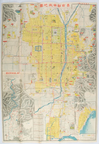
最新京都市街地圖. [Saishin Kyōto shigai chizu].
[Most Recent Map of Kyoto City].
京都. [Kyoto]. 山中書房. [Yamanaka Shobō]. 大正 11 [ 1922]. Stock ID #171899 This 1922 colour folding tourist map of Kyoto offers sightseeing information, each panel showing a photographic monochrome image of the site discussed. When referring to this item please quote stockid 171899.
Attractive colour folding map of Kyoto with a quite detailed illustrated tourist guide printed in blue and white on the reverse, some light browning, holes at some folds, good copy. 78.5 x 54cm,
The two inset maps on the Kyoto map, show Otsu city on the shore of Lake Biwa and the Arashiyama area, north of Kyoto. The main map highlights the major temples and famous sights in red, geographic features, such as rivers and hills are shown and an inset chart shows distances of sights from the nearby stations. The information on the reverse gives more detail on the famous sights, a calendar of events, seasonal highlights and details of the Imperial graves around Kyoto.
Price: $225.00 AU