![Stock ID #173266 上海 支那江蘇省・浙江省. [Japanese Map - Shanghai, Jiangsu Province and Zhejiang Province]. EMPIRE OF JAPAN. 大日本帝国陸地測量部 LAND SURVEY DEPARTMENT.](https://asiabookroom.cdn.bibliopolis.com/pictures/173266.jpg?width=768&height=1000&fit=bounds&auto=webp&v=1699561941)
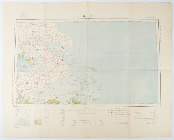
上海 支那江蘇省・浙江省.
[Japanese Map - Shanghai, Jiangsu Province and Zhejiang Province].
[Tokyo]. 大日本帝國陸地測量部. [Dainihon Teikoku Rikuchi Sokuryōbu]. Taisho 15. [ 1926]. Stock ID #173266 This very detailed map was originally surveyed by the Land Survey Department, Empire of Japan in Taisho 7 (1918). This revised edition features the railway line connecting Hangzhou - Jiashan - Shanghai - Suzhou - Wuxi. When referring to this item please quote stockid 173266.
Folding colour Japanese map of Shanghai and coastal areas of Jiangsu and Zhejiang Provinces. Scale 1:100,000, embossed stamp lower right corner. Legend lower edge showing different landforms on the left section (forests, deserts, wildlands, plateaus, rivers and lakes), middle section showing various facilities such as post offices, telecommunication offices, temples, ancestral halls, ancient battle ground, mines, military fortifications, submarine communications cables, city walls and gates, etc.), right section showing different sizes of cities, towns and villages and administrative boundaries.
Occasional foxing along edges and folds, ink annotation in Kanji on reverse, good copy. Text in Japanese. Sheet measures 45.2 x 57.7cm.
Price: $425.00 AU