![Stock ID #176102 大東亜共栄パノラマ地図. [Daitōa kyōei panorama chizu]. [Pictorial Map of the Greater East Asia Co-Prosperity Sphere]. KAZUSHI HARA, 原一司.](https://asiabookroom.cdn.bibliopolis.com/pictures/176102.jpg?width=768&height=1000&fit=bounds&auto=webp&v=1699562905)
![大東亜共栄パノラマ地図. [Daitōa kyōei panorama chizu]. [Pictorial Map of the Greater East Asia Co-Prosperity Sphere].](https://asiabookroom.cdn.bibliopolis.com/pictures/176102_2.jpg?auto=webp&v=1699562905)
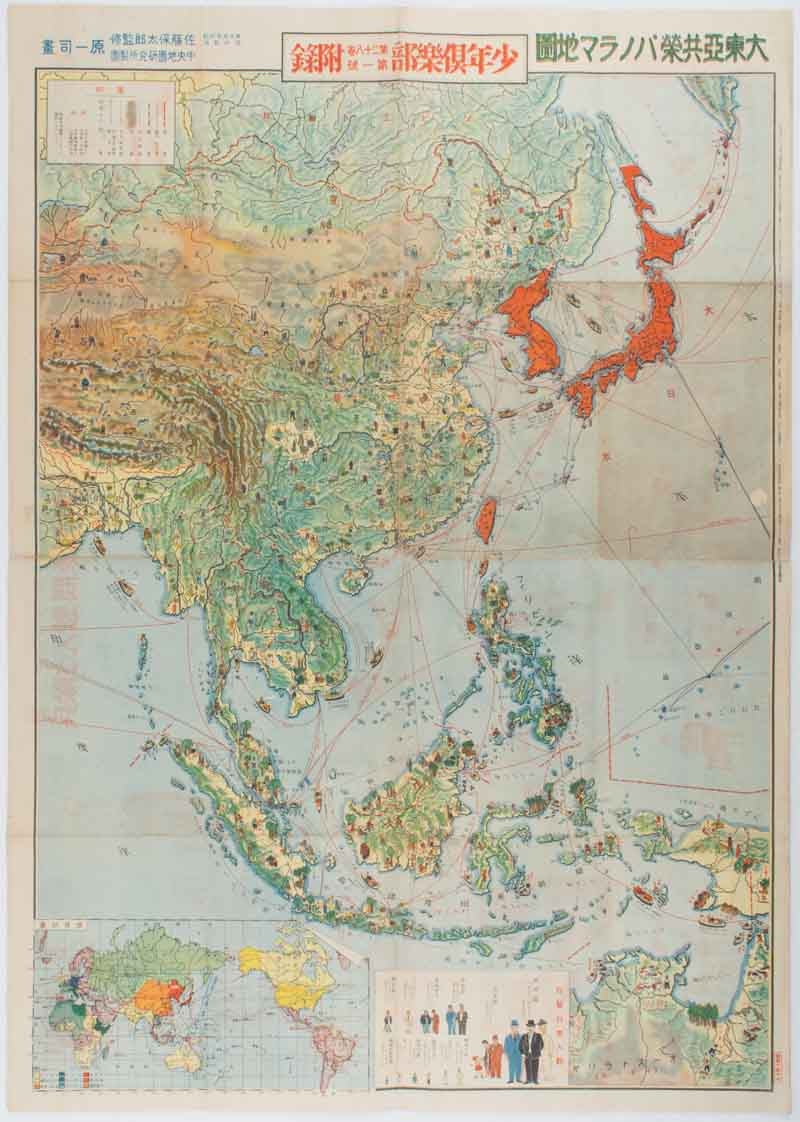
大東亜共栄パノラマ地図. [Daitōa kyōei panorama chizu].
[Pictorial Map of the Greater East Asia Co-Prosperity Sphere].
東京. [Tokyo]. 大日本雄辯會講談社 [Dainihon Yūbenkai Kōdansha]. Showa 16 [ 1941]. Stock ID #176102 A pictorial map of the Greater East Asia Co-Prosperity Sphere, designed for Japanese children and published in 1941. This was issued as a supplement to an edition of "Shonen Kurabu" (Boys' Club), a popular children's magazine published by Kodansha, which included manga, adventure stories etc. The map is clearly designed to foster pride in Japan's overseas influence, as well as educating the young about the region. When referring to this item please quote stockid 176102.
Colour folding pictorial map, inset map and attractively illustrated chart, 75 x 53.5cm. Some browning along folds and repaired small holes along the central fold, small circular section of abrasion, a little offsetting from illustrations of postcards on reverse but overall very good.
The map covers Japan and its colonies (Taiwan, Korea and Karafuto), Southeast Asia as far as Papua, the northern tip of Australia in the east and Burma and Tibet in the west, and China, Manchuria and Mongolia. Japan and its colonies - coloured a vivid orange-red, are undecorated, but the rest of the 'Co-Prosperity Sphere' is adorned with a mass of small images depicting local people engaged in various occupations typical of their region - farming, herding animals, mining, navigating boats etc.
In the section covering Southeast Asia in particular there are also representations of typical local housing styles. The small section covering Arnhem Land and Cape York in Australia is decorated with images of cattle and sheep farming, gold mining, kangaroos, and Japanese pearl fishing vessels. An inset show the number of Japanese residents in various parts of the 'Co-Prosperity Sphere', illustrated by pictures of human figures of varying sizes. 'Japanese' here clearly includes Koreans, since the figures in the inset include not only men in suits and ties (presumably representing ethnically Japanese men), but also a figure in traditional Korean costume. A small inset map also shows the Greater East Asia Co-Prosperity Sphere in a global context, illustrating transport links to various parts of the rest of the world.
Twenty-two illustrated samples of picture postcards to be sent to fighting soldiers at the front is printed on reverse. The readers are encouraged to send postcards with their own illustrations containing patriotic messages. Instructions on how to write the unit address is shown so that the card will be delivered to the front line.
Price: $495.00 AU