![Stock ID #177448 列強大戦争地図. [Rekkyō daisensō chizu]. [War Map of the Great Powers]. OSAKA MAINICHI SHINBUNSHA, 大阪毎日新聞社.](https://asiabookroom.cdn.bibliopolis.com/pictures/177448.jpg?width=768&height=1000&fit=bounds&auto=webp&v=1709611280)
![列強大戦争地図. [Rekkyō daisensō chizu]. [War Map of the Great Powers].](https://asiabookroom.cdn.bibliopolis.com/pictures/177448_2.jpg?auto=webp&v=1709611280)
![列強大戦争地図. [Rekkyō daisensō chizu]. [War Map of the Great Powers].](https://asiabookroom.cdn.bibliopolis.com/pictures/177448_3.jpg?auto=webp&v=1709611281)
![列強大戦争地図. [Rekkyō daisensō chizu]. [War Map of the Great Powers].](https://asiabookroom.cdn.bibliopolis.com/pictures/177448_4.jpg?auto=webp&v=1709611281)
![列強大戦争地図. [Rekkyō daisensō chizu]. [War Map of the Great Powers].](https://asiabookroom.cdn.bibliopolis.com/pictures/177448_5.jpg?auto=webp&v=1709611281)
![列強大戦争地図. [Rekkyō daisensō chizu]. [War Map of the Great Powers].](https://asiabookroom.cdn.bibliopolis.com/pictures/177448_6.jpg?auto=webp&v=1709611281)
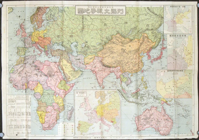
列強大戦争地図. [Rekkyō daisensō chizu].
[War Map of the Great Powers].
大阪. [Osaka]: 大阪毎日新聞社. [Osaka Mainichi Shinbunsha]. Taisho 3 [ 1914]. Stock ID #177448 A particularly detailed and finely printed map which was published in August 1914 shortly after the First World War started. In many ways, the map predicts how the power conflicts among the nations would languish the war before its resolution. The map was a supplement to Osaka Mainichi Newspaper on 21 August 1914. Interestingly, even though the war was still confined to Europe at this stage, the map covers quite a large area, including Asia, Africa, Russia, Japan and Australia. Each nation is coloured according to its alliance as European colonies were spread throughout the world at this stage. Inset maps include "French and German war plane airstrips", "Location of Forts on Border Areas. The inset chart on lower left gives detailed breakdown of Army troop strength of European nations that were at the war. When referring to this item please quote stockid 177448.
Color map, 54 x 77 cm, 4 inset maps. Little loss to lower left vertical fold, couple of other very small spots of loss (no crucial information lost), very light spotting to a couple of panels not visible on front of map; map appears to have been refolded at some point. Good, clean and bright condition.
Price: $475.00 AU