Maps

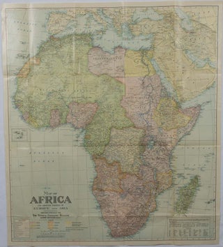
Map of Africa and adjoining portions of Europe and Asia.
Washington, D.C. National Geographic Society. 1922. Large folding printed colour map, 77.2 x 69.4 cm, small inset map of Cape Verde Island, note to the transliteration of place-names, reference key to railways, caravan routes as well as river systems, waterways and deserts, legend to Colonial or territorial control, original folds..... More
![Stock ID #219404 最新大東京全図. [Saishin dai Tokyo zenzu]. [Cover title]. [Most...](https://asiabookroom.cdn.bibliopolis.com/pictures/219404.jpg?width=320&height=427&fit=bounds&auto=webp&v=1760357273)
最新大東京全図. [Saishin dai Tokyo zenzu]. [Cover title]. [Most Recent Map of Greater Tokyo].
東京. [Tokyo]. 東京地図出版株式会社. [Tokyo Chizu Shuppan Kabushikigaisha]. (Circa 1963). Colour folding map, scale 1: 62000, inset maps, text and a map on reverse, loosely inserted in colour light card wrapper. Some tears and a little minor loss along folds, washi repairs along folds on reverse and at spine of card..... More
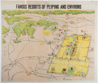
Famous Resorts of Peiping and Environs.
[Peiping]. [Science Press]. (Circa 1930s). Folding printed colour pictographic/pictorial map on blue-print paper, 34.2 x 45cm, 39.2 x 46.8cm (sheet). Wear and loss to the top margin (not affecting the caption), the sheet a little toned and the map slightly offset, but in good condition. Scarce and unusual bird's-eye view..... More
![Stock ID #177140 最新世界大地図. [Saishin sekai daichizu]. [The Newest Map of the...](https://asiabookroom.cdn.bibliopolis.com/pictures/177140.jpg?width=320&height=427&fit=bounds&auto=webp&v=1752071938)
最新世界大地図. [Saishin sekai daichizu]. [The Newest Map of the World].
大阪. [Osaka]. 大阪朝日新聞社. [ Ōsaka Asahi Shinbunsha]. Showa 8 [ 1933]. Colour folding map with maps bordering the map top and bottom, 78 x 108 cm, folded 28 x 20cm. Some old repairs to fold points on the verso, and later repairs with archival washi. Some age-toning to the reverse..... More
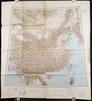
China.
[Calcutta]: Compiled and drawn by the Survey of India. 1945. Second Edition. Large folding colour map, 77.5 x 80cm; 95.5 x 86.2cm (sheet, including legend and small inset showing adjoining maps), light toning and wear to upper margins and at corners and folds; but in very good condition. Very large..... More

Carte Touristique de Pekin. (Tourist Map of Peking).
Editions cartographiques. 1957. Broadside, 75 x 53cm folding to 18 x 12.5cm, total of ten colour maps printed on both sides of sheet. A few ink annotations in French on maps, light wear to cover, couple of splits at folds, now repaired with archival tape, good condition. A most interesting..... More
![Stock ID #176313 GinzaいらすとMap. [Ginza irasuto mappu]. 1970S TOKYO](https://asiabookroom.cdn.bibliopolis.com/pictures/176313.jpg?width=320&height=427&fit=bounds&auto=webp&v=1757653987)
GinzaいらすとMap. [Ginza irasuto mappu].
Tokyo. 銀実会. [Ginjitsukai]. 1975. Delightful brightly coloured pictorial folding map of Ginza in the mid 1970s. 53.2 x 75cm. Text in Japanese. A delightful and colourful illustrated map of the Ginza entertainment area of Tokyo, published in 1975. The designer's name is given as A. Shibata. One side of the..... More
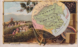
Chinese Empire.
New York. Arbuckle. [ 1889]. Chromolithograph light card featuring a fan shaped map of the Chinese Empire in the foreground with a tea picking scene in the background. Faint browning on reverse. A lovely example of a late 19th century chromolithograph. This fan shaped map of China was issued as..... More

China Sea. Northern Portion, Western Sheet. [Hong Kong to Cape Padaran, Cochin China].
London. Admiralty. 1929. Large black and white coastal chart, 103 x 70.5cm, horizontal fold, a little light browning and soiling, neat manuscript highlighting beacons, good copy. Compiled from the latest surveys to 1884 corrected to 1929, with a large correction in 1926. Includes arrows indicating the direction and strength of..... More

China - East Coast. Approaches to the Yang Tse Kiang.
London. Admiralty. 1905. Reissue. Large Admiralty chart, 69 x 103.5cm. Vertical central fold with slight damp stain upper margin, neat manuscript notation in pencil on margin, 12 cm repair to closed tear at foot of central fold, some light browning, a good copy with light wear on extremities. Corrected to..... More
![Stock ID #177068 Africa [and] N. W. Africa, Morocco, Algeria & Tunis. AFRICA - MAP, GEORGE F. CRAM](https://asiabookroom.cdn.bibliopolis.com/pictures/177068.jpg?width=320&height=427&fit=bounds&auto=webp&v=1757654023)
Africa [and] N. W. Africa, Morocco, Algeria & Tunis.
Chicago. Geo. F. Cram. ( 1894). Chromolithographed maps, 54.3 x 34.1 cm (sheet), central fold, a few small edge tears and marginal age toning, but in very good condition. Detailed maps prepared for George F. Cram's 1894 "Standard American Atlas": one of the first American firms to publish a world..... More

Africa and the Adjacent Islands.
New York. Ivison, Blakeman, Taylor & Co., (circa 1877). Printed colour map, 27.5 x 21.7 cm, large inset of Northern Africa and a smaller of Southern Africa, two small edge tears, lower corner neatly strengthened, the sheet toned, but the map in good condition, unrelated text printed on the verso..... More

Africa, North-East.
(London). (Times Atlas of the World). ( 1895). Double-page folding map, printed in colour, 46.5 x 36.5 cm. edges gilt, central fold, with an inset map of Somaliland (Somalia) and the island of Sokotra, key to European possessions outlined in colour, small edge fold tears affecting the margin only and..... More

Africa.
[New York]. Rand, McNally & Co., 1899. Printed colour map, 36.3 x 24.3 cm, inset map of the Suez Canal and two smaller insets of the Cardagos Crayos Islands, Mascarene Islands and Cape Verde Islands, central fold, and on the verso a printed panel listing the countries in Africa with..... More

South Africa.
Edinburgh & London. W. & A. K. Johnston. (circa 1877). Printed colour map, 25 x 32.5 cm, edge tears, one affecting the lower border only, two small chips from the upper margin, corner repaired, the map in very good condition. Map of North America with a small inset of the..... More

Africa.
London. The London Printing and Publishing Company. [Circa 1880s]. Printed map, 24 x 32.1 cm, decorative border, two original vertical folds, paper toned, mainly at the edges, inner margin of the sheet ragged, but in good order. A late edition of the map used for the well-known Tallis map, this..... More

Physical and Political Map of Africa.
New York. Harper & Brothers. [circa 1877]. Chromolithographed map with outlne handcolour, 27.1 x 21 cm, major towns marked with a red cross, relief by hachures, ocean currents marked, two inset maps of the Suez canal and Mascarene Island, two very small marginal edge tears not affecting the map, slight..... More
![Stock ID #179415 北米合衆国全図. [Hokubei Gasshūkoku zenzu]. [Map of the United...](https://asiabookroom.cdn.bibliopolis.com/pictures/179415.jpg?width=320&height=427&fit=bounds&auto=webp&v=1752072583)
北米合衆国全図. [Hokubei Gasshūkoku zenzu]. [Map of the United States of America].
[Tokyo]. 楠山正雄. [Kusuyama Masao]. Meiji 44 [ 1911]. Colour folding map, 40 x 55cm, inset maps showing the Philippines, Alaska and Hawaii, very good copy. This map was a supplement of October 1911 issue of a monthly magazine Shin Nippon (新日本), which was published between 1911 and 1918. The main..... More

Monde comm des Anciens.
(Paris.): (circa 1820). Engraved map with original outline hand-colour, 21.1 x 31.5cm, original folds, a few spots and a little creased but in very good condition. Latin map of the Ancient world encompassing Europe, India, Arabia, the Middle East and North Africa, by the French cartographer Jean Baptiste Poirson (1761-1831)..... More

Central Asia.
(Philadelphia). (John Conrad & Co.), ( 1804). Engraved map, 24.3 x 39.5 cms; 26.9 x 44.2 cms (sheet), relief indicated with hachures, original folds, numbered in ink "27" in top corner (faded), minor edge-toning otherwise in very good condition. An uncommon Arrowsmith map of Central Asia "From Du Halde, D'Anville..... More

Johnson's China.
(New York). Johnson and Ward. (circa 1864). Handcoloured map, 32 x 39.8 cms (including decorative border); 35.5 x 46 cms (sheet), insets of the harbor and island of Amoy and Canton and adjacent islands, unrelated text on the verso, very slight age toning, clean and bright in very good condition..... More
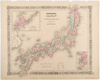
Johnson's Japan, Nippon, Kiusiu, Sikok, Yesso and the Japanese Kuriles.
Johnson and Ward. (circa 1865). Hand coloured map, 32.6 x 39.7 cms (including the decorative border); 36.8 x 45.8 cms (sheet), two inset maps, "Yesso and the Japanese Kuriles" and "Bay of Nagasaki", scant spotting, sheet age toned and a few marginal chips and tears (not affecting the map), in..... More

Johnson's Japan, Nippon, Kiusiu, Sikok, Yesso and the Japanese Kuriles.
Johnson and Ward. (Circa 1863). Hand coloured map, 32.6 x 39.7 cms (including the decorative border); 36.8 x 45.8 cms (sheet), two inset maps, "Yesso and the Japanese Kuriles" and "Bay of Nagasaki", unrelated printed text on the verso, sheet very slightly age toned, scant marginal spotting, in very good..... More
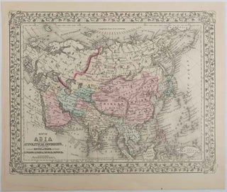
Map of Asia Showing its Gt. Political Divisions and also the Various Routes of Travel Between London & India, China & Japan &c. [with] Map of Persia, Arabia, Turkey in Asia, Afghanistan, Beloochistan.
Pennsylvania. 1879. Lithographed maps on two sides of a single leaf with original hand-colouring, 27 x 34 cms (map size) 31.1 x 37.1 cms (sheet) with a finely-engraved foliated border, margins age-toned, one margin tide-marked at the edge (not affecting the maps), a handsome pair of maps in very good..... More