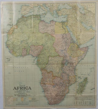
Map of Africa and adjoining portions of Europe and Asia.
Washington, D.C. National Geographic Society. 1922. Large folding printed colour map, 77.2 x 69.4 cm, small inset map of Cape Verde Island, note to the transliteration of place-names, reference key to railways, caravan routes as well as river systems, waterways and deserts, legend to Colonial or territorial control, original folds..... More
![Stock ID #219404 最新大東京全図. [Saishin dai Tokyo zenzu]. [Cover title]. [Most...](https://asiabookroom.cdn.bibliopolis.com/pictures/219404.jpg?width=320&height=427&fit=bounds&auto=webp&v=1760357273)
![Stock ID #177140 最新世界大地図. [Saishin sekai daichizu]. [The Newest Map of the...](https://asiabookroom.cdn.bibliopolis.com/pictures/177140.jpg?width=320&height=427&fit=bounds&auto=webp&v=1752071938)

![Stock ID #176313 GinzaいらすとMap. [Ginza irasuto mappu]. 1970S TOKYO](https://asiabookroom.cdn.bibliopolis.com/pictures/176313.jpg?width=320&height=427&fit=bounds&auto=webp&v=1757653987)


![Stock ID #177068 Africa [and] N. W. Africa, Morocco, Algeria & Tunis. AFRICA - MAP, GEORGE F. CRAM](https://asiabookroom.cdn.bibliopolis.com/pictures/177068.jpg?width=320&height=427&fit=bounds&auto=webp&v=1757654023)


![Stock ID #64215 Thietmarsiae, Holsaticae Regionis Partis Typus. Auictore Petro Boeckel [with]...](https://asiabookroom.cdn.bibliopolis.com/pictures/64215.jpg?width=320&height=427&fit=bounds&auto=webp&v=1754690954)
![Stock ID #177991 萬国訳図. 西半球. [Bankoku yakuzu. Nishi hankyū]. [International...](https://asiabookroom.cdn.bibliopolis.com/pictures/177991.jpg?width=320&height=427&fit=bounds&auto=webp&v=1779173165)